Welcome to Nusail Surveys

Looking for top-quality surveying services in Oman? Nusail Survey is your go-to expert for GIS, elevation mapping, land surveyor jobs, and more. We specialize in hydrographic and topographic surveys, including 3D laser scanning, mobile mapping, and drone surveying. Our team is skilled in land and bathymetric surveys, providing precise data for your projects. We use the latest drone technology for land and topographic mapping. Working closely with Oman's national survey authority, we ensure reliable and accurate remote sensing services for all your survey needs.

Get Started

Expert Land and Hydrographic Survey Services by NUSAIL Engineering Consultancy

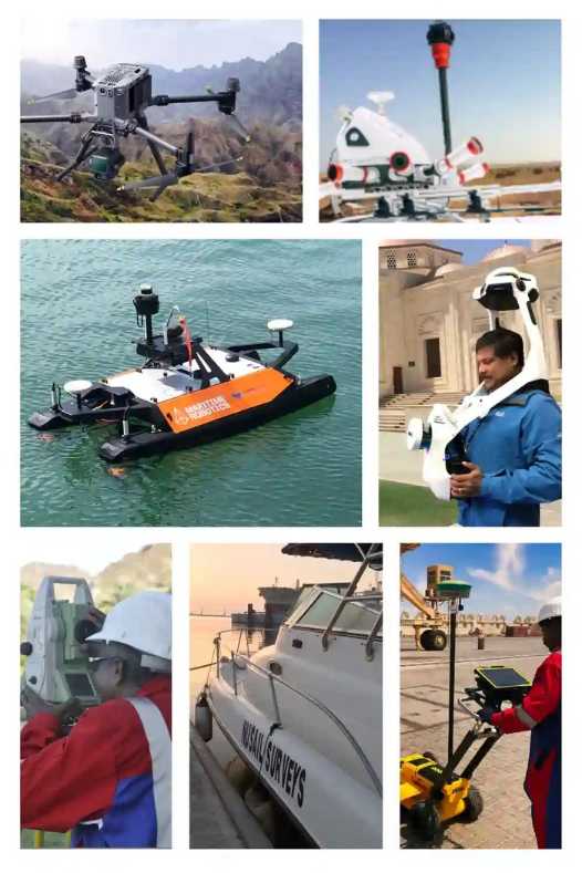
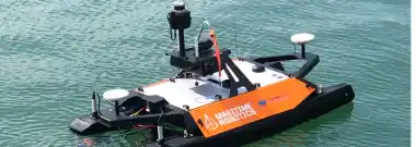
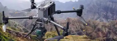
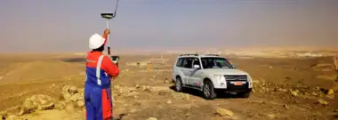
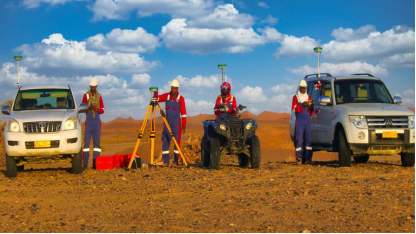
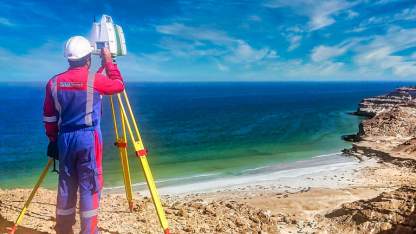
At NUSAIL Engineering Consultancy, we are at the forefront of revolutionizing the field of surveying, combining over 20 years of expertise with cutting-edge technology. From the heart of the Sultanate of Oman to the expanses of the UK and Saudi Arabia, our services span GIS, topographic surveying, hydrographic surveys, and bathymetric surveys, setting the standard for excellence in the industry. Our dedicated professionals are committed to delivering precise and reliable surveys, utilizing advanced 3D laser scanning, drone surveying, and mobile mapping to capture accurate data for various applications. Our expertise in land surveyor jobs in Oman and beyond demonstrates our capability to adapt to the diverse needs of our clients, ensuring the highest quality of service.

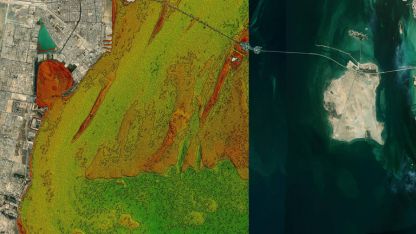
NUSAIL Engineering Consultancy is not just a name; it's a promise of quality, innovation, and dedication. Our use of land survey drones and alignment with the National Survey Authority of Oman's standards reflect our commitment to precision and excellence. As a leading bathymetric survey company, we offer specialized insights into underwater topographies crucial for marine and coastal projects. Our comprehensive solutions in Geographic Information Systems (GIS), highway, road, and geotechnical engineering are tailored to meet the rigorous demands of today's construction and environmental management projects. We are for those seeking land surveyor vacancies in Oman, offering opportunities to be part of a team that stands on the cutting edge of surveying technology.

At NUSAIL Engineering Consultancy, our dedication to leveraging the most advanced technologies, such as NavVis SLAM and the RIEGL VMX-2HA, underscores our commitment to delivering unparalleled accuracy, efficiency, and value to our clients. Through these innovative tools, we continue to push the boundaries of what's possible in surveying, ensuring that our clients receive the most reliable and detailed data for their projects. Our approach integrates cutting-edge mobile mapping systems and sophisticated SLAM technology to navigate and map unknown environments with unprecedented precision. The RIEGL VMX-2HA, a high-speed, dual-scanner mobile mapping system, captures millions of measurements per second, offering survey-grade data at highway speeds. This commitment to employing the latest in survey technology places NUSAIL at the forefront of the industry, providing our clients with superior surveying solutions that meet their needs with accuracy and efficiency.

Drone Topographic survey

OUR SERVICES

Precision Surveying: Reliable, Expert Services

Hydrographic and Oceanographic Surveys

Hydrographic and Oceanographic Surveys

NUSAIL Engineering Consultancy specializes in accurate underwater data through hydrographic and oceanographic surveys. Our expertise supports sustainable development and management.

Learn more
Mobile Mapping Applications

Mobile Mapping Applications

NUSAIL Engineering Consultancy is a leader among mobile mapping companies, utilizing advanced mobile mapping systems to deliver precise geospatial data. Our mobile mapping applications streamline the collection of detailed terrain and infrastructure information, enhancing accuracy and efficiency for a variety of projects.

Learn more
GIS and Remote Sensing

GIS and Remote Sensing

NUSAIL leverages GIS and Remote Sensing for strategic planning and resource management, transforming geospatial data into actionable insights.

Learn more
3D Laser Scanning Surveys

3D Laser Scanning Surveys

NUSAIL Surveys employs cutting-edge 3D laser scanning for precise mapping and infrastructure surveys, ensuring accurate results.

Learn more
Drone Aerial Surveying and Geo-Mapping

Drone Aerial Surveying and Geo-Mapping

Nusail utilizes drone technology for high-resolution terrain mapping and accurate data collection, enhancing project precision.

Learn more
Land Surveying / Topographic Survey

Land Surveying / Topographic Survey

NUSAIL specializes in Land and Topographic Surveys, offering precise Earth's surface measurements for project development.

Learn more
Utility Survey

Utility Survey

NUSAIL offers Utility Surveys for accurate underground utility mapping, ensuring safe and efficient project management.

Learn more

Why You Should Trust Us? Learn More About Us!

Trust our expertise in surveying, as we combine cutting-edge technology, a client-centric approach, and a highly skilled team to deliver precise, reliable, and innovative surveying solutions tailored to your project needs. Experience the NUSAIL difference for yourself!

Design Approach

NUSAIL Engineering Consultancy combines client collaboration, technological innovation, and multidisciplinary expertise to provide tailored, precise surveying solutions across a wide range of services, ensuring successful project outcomes

Innovative Solutions

Innovative Solutions specializes in advanced, precise surveying techniques, leveraging cutting-edge technology and expertise to provide tailored services, ensuring client satisfaction and successful project completion.

Project Management

Project management skillfully orchestrates planning, execution, control, and closure of projects, achieving objectives within set timelines and budgets. This process optimizes resources, tasks, and stakeholder collaboration, ensuring project success

Team Members

We Are Committed To Delivering The Best Engineering And Surveying Solutions

Issa Al Barmani

Issa Mohammed Ali Al Barmani is the Director of Nusail Engineering Consultancy, bringing a wealth of expertise and over two decades of experience in managing construction projects, particularly in the areas of ports and harbors. He holds a BSc in Civil Engineering from Sultan Qaboos University and an International Port Harbour Association (IPHA) certificate in Port and Harbour Engineering from Japan. Issa has also undergone GIS training and an English course in the UK. His ability to manage multiple contracts and projects, review design specifications, and prepare tenders has been invaluable to our clients. Under his leadership, Nusail Engineering Consultancy has become a trusted name in the industry.

  • +968 99455223.
  • issa@nusailec.com
Issa Al Barmani

Manjini Anandaraj

Manjini Anandaraj has over 25 years of experience managing and analyzing GIS data, civil engineering, remote sensing, and marine/geometric surveying. He has worked extensively in the United Kingdom, Oman, and Saudi Arabia, and is highly skilled in using various software such as ArcGIS Pro, Terrset, AutoCAD Civil 3D, and Bentley Microstation V8i for map preparation, utilities, and highway modeling. In addition, his expertise extends to 3D scanning and drone data processing using Leica Cyclone and Pix4D. Manjini holds a Master of Science in Geographic Data Science from Birkbeck, University of London, and a Bachelor of Technology in Civil Engineering . He is also a member of various professional institutions.

  • +44 7440309646
  • anand@nusailec.com
Manjini Anandaraj

Sayeed

Mohammed Sayeed Ahmed is an experienced Engineering Surveyor with over 25 years of Gulf experience in land surveying. He specializes in surveys for infrastructure, highways, bridges, pipe lines, seawall construction, high-rise towers, hotels, villas, and industrial projects. As Operations Director at Nusail Engineering Consultancy, he manages topographic surveys, bathymetric surveys, 3D laser scanning, aerial survey-geo mapping using UAV, GIS, and highway design. Previously, he worked at Carillion plc Qatar as Chief Surveyor, managing the Msheireb Doha Downtown Phase 1B project with 15 buildings, a mosque, and external works. Mohammed holds a Bachelor of Engineering in Civil from Osmania University, Hyderabad, India.

  • +968 99209610
  • sayeed@nusailec.com
Sayeed

M.T. Sangy

M.T. Sangy is a highly successful professional, with a Master's degree in Business Psychology and a Master's degree in Research from King's College London, UK. Since 2005, she has played an integral role in the growth and success of Nusail Engineering Consultancy. With extensive experience in the engineering consultancy industry, M.T. Sangy has developed exceptional skills in business development and organizational psychology. She is highly skilled in identifying new business opportunities and developing successful marketing strategies. M.T. Sangy's exceptional academic background and professional experience make her a valuable asset to Nusail Engineering Consultancy.

  • +44 7958448160
  • lee@nusailec.com
Lee

Our Projects

  • All
  • Hydrographicandf Oceanographic Surveys
  • Land Surveying / Topographic Survey
  • GIS and Remote sensing
  • 3D Laser Scanning Surveys
GPS Survey

Topographic Survey

Topographic Survey

Land Surveying / Topographic Survey

GIS

GIS

3D Scanner Survey

3DS

current Meter ADCP

Environmental

F

Bathymetric survey

Nusail HSE

Drone Topographic Survey

Testimonials

Our Services Are Trusted By All Customers Who Have Chosen To Work With Us

Our Clients

Worley Company Oman London UK
Atkins Company Oman London UK
Parsons Company Oman London UK
Fugro Company Oman London UK Saudi Arabia
Suez Company Oman London UK Saudi Arabia
Ayesa Company Oman London UK Saudi Arabia
Veolia Company Oman London UK Saudi Arabia
Oman Air Company Oman London UK Saudi Arabia
PDO Company Oman London UK Saudi Arabia
Omran Company Oman London UK Saudi Arabia
Duqm Company Oman
Petrofac Company Oman London UK Saudi Arabia
KEO Company Oman London UK Saudi Arabia
Technip Company Oman London UK Saudi Arabia
Sering Company Oman London UK Saudi Arabia
Wood Company Oman London UK Saudi Arabia
Saraya Bander Jissah Company Oman London UK Saudi Arabia
Vinci Company Oman London UK Saudi Arabia
WSP Company Oman London UK Saudi Arabia
Oman PWP Company Oman London UK Saudi Arabia
STFA Company Oman London UK Saudi Arabia
Fitchner Company Oman London UK Saudi Arabia
Sarooj Company Oman London UK Saudi Arabia
Carillion Company Oman London UK Saudi Arabia
ASYAD Company Oman London UK Saudi Arabia