Remote Sensing Services And GIS Data Services
Remote Sensing Services
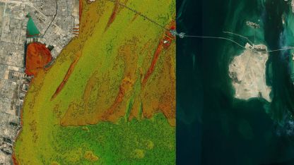
Satellite-Derived Bathymetry (SDB)
SDB is a technique that uses multispectral satellite imagery to estimate water depth in shallow areas. This method allows for large-scale, cost-effective bathymetric mapping, which is crucial for nautical charting, coastal zone management, and marine habitat studies.
Topographic Mapping
Topographic mapping involves the creation of accurate and detailed maps depicting the Earth's surface features, including elevation data, natural features, and man-made structures. These maps are essential for planning, engineering, environmental management, and other applications.
Land Use Land Cover (LULC) Mapping
LULC mapping involves the classification and mapping of land use and land cover types based on satellite imagery. It provides essential information for urban planning, natural resource management, agricultural development, and environmental assessment.
Satellite Mapping
Satellite mapping refers to the process of acquiring, processing, and interpreting satellite imagery to produce accurate and detailed maps. It is used in various applications, such as disaster management, natural resource monitoring, and environmental assessments.
Habitat and Ecological Mapping and Classification
Habitat and ecological mapping involves the identification, classification, and mapping of ecosystems and habitats based on remote sensing data. This information is critical for conservation planning, wildlife management, and ecosystem restoration efforts.
Terrain Mapping
Terrain mapping is the process of creating detailed and accurate maps of the Earth's surface, including elevation data and surface features. These maps are essential for various applications, such as infrastructure development, natural hazard assessment, and military operations.
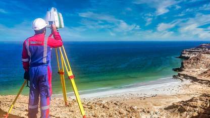
Marine Environment Mapping (Seabed and Benthic)
Marine environment mapping involves the detailed mapping and characterization of the seabed and benthic habitats. This information is crucial for marine spatial planning, environmental impact assessments, and the management of marine protected areas.
Air Quality Mapping
Air quality mapping uses remote sensing techniques to monitor and map air pollutants and their distribution over time. This information is vital for environmental monitoring, air quality management, and public health assessments.
Heat Mapping
Heat mapping involves the collection and visualization of thermal data to identify temperature patterns across a landscape. It is used in various applications, such as urban heat island assessment, energy efficiency planning, and environmental monitoring.
Social, Economic, and Political Mapping
Social, economic, and political mapping involves the spatial representation and analysis of various social, economic, and political indicators. This type of mapping helps inform policy-making, resource allocation, and decision-making in various sectors, such as public health, education, and urban planning.
GIS Data Services
Data Capture & Conversion
Data capture and conversion involve collecting geospatial data from various sources, such as satellite imagery, aerial photography, and field surveys, and converting it into a compatible GIS format. This process ensures accurate and up-to-date information is available for analysis and decision-making.
GIS Database Design
GIS database design focuses on creating a structured and organized geospatial database to store, manage, and analyze spatial data. A well-designed GIS database improves data integrity, query efficiency, and overall system.
GIS Data Sourcing
GIS data sourcing involves the acquisition of spatial data from various sources, such as government agencies, private organizations, and open data repositories. This process ensures that high-quality, relevant, and up-to-date data is used for GIS projects and analysis.
GIS Analysis and Reporting
GIS analysis and reporting involve the processing and interpretation of spatial data to extract meaningful insights and generate reports. This information supports decision-making, policy formulation, and resource management in various fields such as urban planning, environmental management, and public health.
GIS Spatial Analysis
GIS spatial analysis involves the use of specialized techniques to analyze and interpret spatial relationships, patterns, and trends in geospatial data. This type of analysis is essential for understanding complex spatial phenomena and informing decision-making processes.
Data Visualisations
Data visualizations are graphical representations of geospatial data, designed to make complex information more accessible and understandable. These visualizations can include maps, charts, and interactive web applications, helping users explore and interpret spatial data effectively.
GIS Map Printing and Finishing
GIS map printing and finishing involve the production of high-quality, large-format maps and other geospatial products. These services ensure that GIS outputs are presented professionally, with clear symbology, accurate scale, and durable materials suitable for various uses.
GIS Consultancy
GIS consultancy services provide expert advice and support for organizations implementing or improving their GIS capabilities. This can include guidance on system design, data management, analysis techniques, and the integration of GIS with other business systems.


