Hydrographic Surveys & Oceanographic Surveys
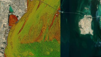
Bathymetric and hydrographic surveys are essential tools for understanding and mapping the underwater environment, ensuring safe navigation, and supporting environmental management. In countries like Oman, Saudi Arabia, and the United Kingdom, bathymetric survey Oman, hydrographic survey Oman, hydrographic survey Saudi Arabia, and hydrographic survey UK are vital for maintaining maritime safety and studying oceanographic phenomena. Bathymetric surveys involve the use of advanced technologies and techniques to measure and map the depth of bodies of water. Hydrographic surveys, which are closely related to bathymetric surveys, provide essential information about underwater hazards and features. These surveys are critical for ensuring safe navigation and environmental management in Oman, Saudi Arabia, and the UK. Oceanographic surveys, on the other hand, are multidisciplinary in nature and involve the study of physical, chemical, and biological characteristics of the ocean. These surveys employ state-of-the-art instruments and methods to collect data on various oceanic parameters, such as temperature, salinity, currents, and marine life. The information obtained from oceanographic surveys is used to improve our understanding of ocean dynamics, ecosystems, and the impacts.
Seabed/Geophysical Surveys
Seabed and geophysical surveys are crucial techniques that help to gather information about the geological features of the seafloor and the underlying layers of sediment and rock. These surveys utilize a variety of advanced instruments such as sonar, magnetometers, and seismic devices to collect data on the physical and chemical properties of the seafloor. The data collected is vital for various applications including marine resource management, offshore infrastructure development, and environmental monitoring.
Single Beam Bathymetry Survey
Single beam bathymetry surveys measure water depth and generate accurate depth profiles of the seabed using a single sonar beam
Multibeam Bathymetry Surveys
Multibeam bathymetry surveys use multiple sonar beams to create detailed, high-resolution maps of the seafloor and its features.
Side Scan Sonar Survey
Side scan sonar surveys use sonar technology to create detailed images of the seafloor and identify objects, structures, and habitats.
Sub-bottom Profile Survey
Sub-bottom profile surveys use acoustic technology to investigate the layers beneath the seafloor, providing valuable geological and sedimentary data.
Magnetometer Survey
Magnetometer surveys detect variations in the Earth's magnetic field to identify buried objects, such as pipelines, cables, and archaeological.
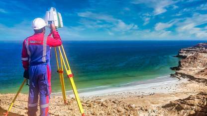
Underwater Positioning
Underwater positioning systems are essential for accurate navigation and data collection during underwater operations and inspections.
Underwater Inspection
Underwater inspections involve the examination of submerged structures, vessels, and other assets for maintenance, safety, and environmental compliance.
Core Sample
Core samples are extracted from the seabed to analyze sediment composition and provide critical information for environmental assessments and infrastructure planning.
Chemical Oceanography
Chemical oceanography is a subfield of oceanography that focuses on the study of the chemical composition and processes occurring in the ocean. It encompasses the measurement and analysis of various chemical parameters such as dissolved oxygen, nutrients, salts, and trace elements, as well as the biogeochemical cycles that regulate these parameters. Chemical oceanographers use a variety of methods and techniques to study the ocean, including remote sensing, field observations, and laboratory experiments. The information obtained from these studies is crucial in understanding the role of the ocean in global biogeochemical cycles, such as the carbon cycle, and how changes in ocean chemistry can impact marine ecosystems and climate. Chemical oceanography plays an important role in addressing environmental issues such as ocean acidification, harmful algal blooms, and the impacts of anthropogenic activities on the ocean.
Water Quality Analysisy
Chemical oceanography studies the composition and distribution of chemical elements in the ocean, providing valuable insights into marine ecosystems and human impacts.
Sediment Quality Analysis
Sediment quality analysis evaluates the composition and contamination levels of sediments in aquatic environments, helping to monitor and manage potential ecological risks
Air Quality Analysis
Soil quality analysis assesses the physical, chemical, and biological properties of soils to determine their health and productivity, as well as potential environmental concerns.
Noise Monitoring
Noise monitoring measures sound levels in marine environments to assess the impact of human activities on marine life and ecosystem health.
Metocean
Metocean refers to the combined study of meteorological and oceanographic conditions in a particular region. It involves the measurement and analysis of various physical parameters such as waves, currents, tides, winds, temperature, and precipitation. Metocean data is used to understand the environmental conditions of a region, which can help in making informed decisions related to offshore activities, such as oil and gas exploration, marine construction, and renewable energy projects. Metocean data is also used in weather forecasting, climate modeling, and marine safety operations.
Waves Analysis
Waves analysis examines wave characteristics, such as height, period, and direction, to predict their impact on coastal infrastructure, navigation, and sediment transport.
Current Analysis
Current analysis investigates ocean currents and their variability to understand their influence on marine ecosystems, sediment transport, and offshore operations.
Winds and Tides
Winds and tides play a significant role in shaping coastal and oceanic environments, affecting navigation, erosion, and the distribution of marine life and nutrients.


