Drone survey Oman
Drone survey and aerial Geo-Mapping
Fast coverage for solar fields, corridors, masterplans and remote terrain where ground-only methods would be slow or costly. Nusail delivers drone survey Oman programmes with photogrammetric processing, QA against control and exports suited to engineering design.

Precision That Soars Above the Rest
Nusail Drone Survey & Geo-Mapping

At Nusail Drone Survey & Mapping, we leverage the latest high-specification drones and industry-leading software to deliver detailed, precision imagery and data for your projects. Our drone surveys provide actionable insights, enabling you to analyze site measurements, calculate volumes, and track progress at every stage of construction with ease.
Why Choose Drone Surveys?
Rapid Data Collection: Capture comprehensive data in hours rather than days, avoiding time-consuming approval processes.
Enhanced Safety: Keep your team off the ground and reduce risks by relying on drones for site inspections and measurements.
Versatile Outputs: Receive survey outputs in any format required for bidding, design, planning, or site monitoring.
Full Site Visualisation: From start to finish, visualise the entire build process, enhancing decision-making and planning efficiency.
Accurate 2D & 3D Survey Data: Benefit from precise data, easily classified into reports and CAD files, ensuring accuracy in construction before final handover.
Change Detection & Progress Tracking: Conduct subsequent surveys to identify changes over time and project cut-and-fill requirements as your project evolves.
Tailored Solutions for Your Project
Our drone survey services are customized to your specific project needs. We guide you through the process and ensure that every survey delivers the accuracy, speed, and efficiency you require.
Which services do YOU need? Contact us today, and let our experts help you choose the best combination of services for your project.
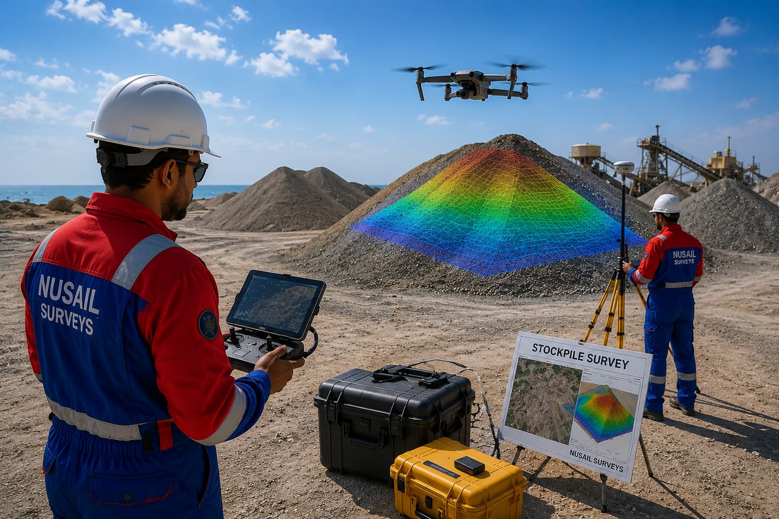
Stockpile Surveys
At Nusail Drone Services, we specialize in providing highly accurate and efficient stockpile surveys for construction sites.
Read more
3D Modelling Inspection
Nusail Drone Services offers cutting-edge 3D modelling inspection solutions, enabling analysis of construction sites.
Read more
CAD Overlays
At Nusail Drone Services, we offer the ability to seamlessly overlay 3-dimensional survey from drone-captured with your existing CAD files.
Read more
Cut and Fill Analysis
Nusail Drone Services provides precise cut and fill analysis to streamline site preparation and earthmoving operations.
Read more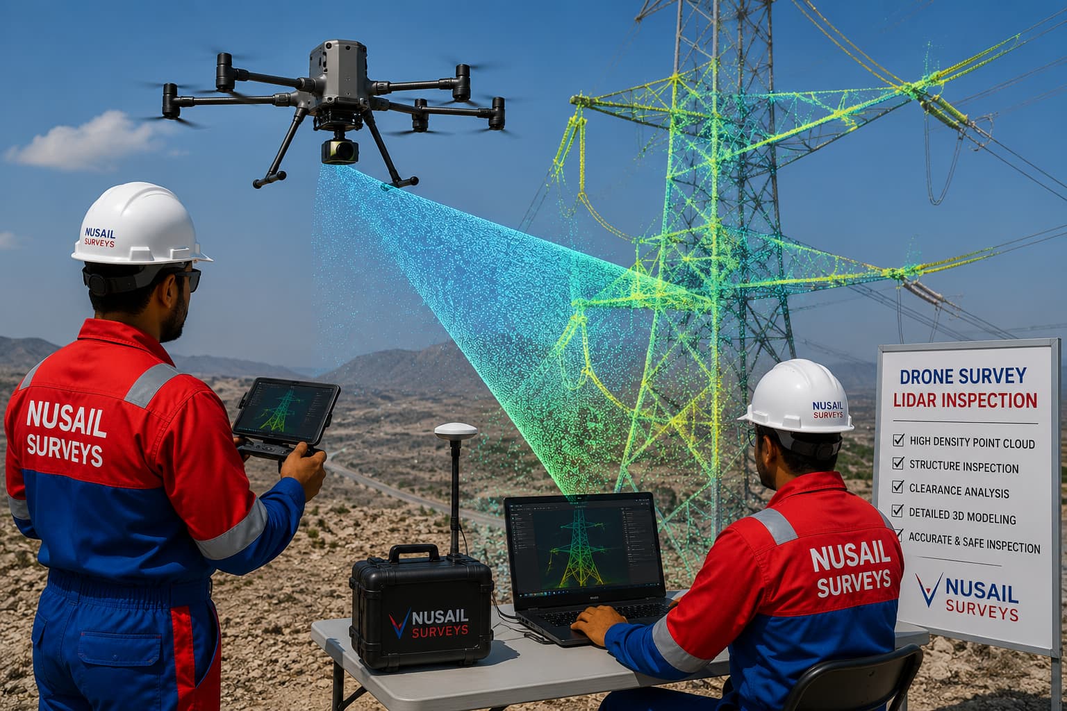
LiDAR Inspection
Nusail Drone Services utilizes LiDAR (Light Detection and Ranging) technology detailed three-dimensional data of construction sites.
Read more
Photogrammetry
At Nusail Drone Services, we employ advanced photogrammetry to capture 3-dimensional information about construction sites.
Read more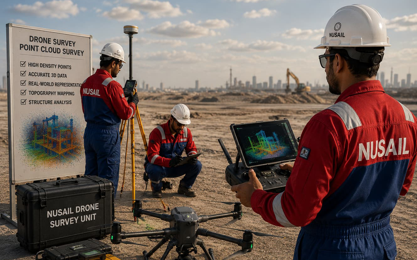
Point Cloud Survey
Nusail Drone Services offers advanced point cloud surveys, capturing millions of data points in a 3-dimensional provide comprehensive site assessments.
Read more
RTK Data
At Nusail Drone Services, we use advanced Real-Time Kinematic (RTK) technology to enhance the accuracy of our drone surveys.
Read more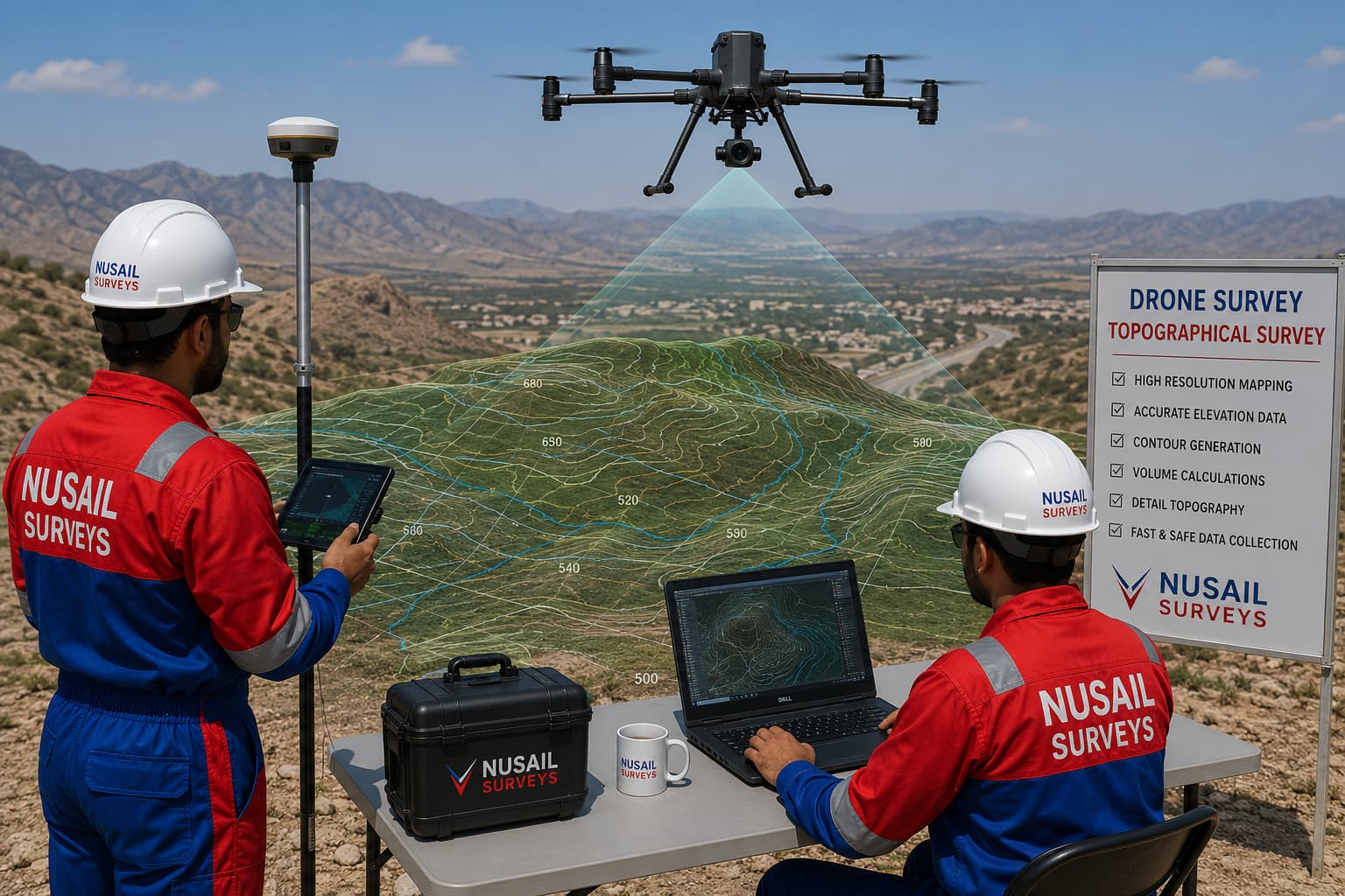
Topographical Survey
At Nusail Drone Services, we conduct precise topographical surveys using drone-based photogrammetry.
Read moreDrone Survey Work process
Simple Step To Survey Success Started Working Process
PRE-FLIGHT
PLANNING
FLIGHT/DATA
CAPTURE
LAUNCHPAD -
CLIENT PORTAL
EAT, SLEEP, DRONE, REPEAT
When drone survey helps
Large hectarage sites, repeating topographic updates and early-stage optioneering often benefit from aerial capture. Drone survey projects Oman in our selected portfolio include renewable and mixed-use developments at substantial scales—representative of the type of commissions we support, subject to site-specific planning.
Outputs
- DTM / DSM and orthophoto mosaics
- Planimetric features where specified
- Integration with ground truth and checkpoints
- CAD and GIS-ready formats
Coordination with other surveys
We frequently combine drone work with utility survey Oman or bathymetric survey Oman on coastal interfaces so clients receive one coherent spatial framework rather than conflicting models.
Related services
Portfolio / Selected case studies
Selected project experience demonstrating Nusail’s capability in land, marine, drone and geospatial survey projects. Full project references can be provided upon request.
Explore drone survey projects Oman and related topographic highlights using the filters below.
Contact / request quotation
Share site area, accuracy requirement, airspace constraints and deadline for a scoped proposal.
Oman office
Building No. 9459A, Way No. 897, Mawaleh North, P.O. Box 143, Postal Code 311, Sultanate of Oman