Single-beam bathymetry
Depth profiles along survey lines for channels, berths and linear assets where programme and scale suit single-beam acquisition.
Hydrographic survey Oman
Hydrographic survey Oman assignments combine seabed measurement with vertical reference and quality documentation suited to marine engineering. Nusail works alongside port authorities, developers and EPC teams where reliable bathymetry underpins design and dredging decisions.
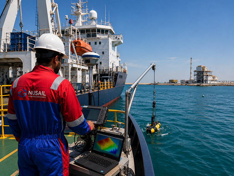
Hydrographic surveys provide comprehensive information about underwater features, seabed conditions, navigational hazards and marine infrastructure. Nusail delivers hydrographic survey services across Oman, Saudi Arabia and the UK to support port development, offshore projects, coastal engineering and marine asset management.
Our hydrographic survey solutions combine bathymetry, side scan sonar, sub-bottom profiling, positioning systems and geophysical investigations to produce accurate marine datasets for planning, design, construction and operational decision-making.
Detailed imaging of the seabed to identify objects, obstructions and underwater structures.
Investigation of subsurface sediment layers and geological formations beneath the seabed.
Detection of buried metallic objects, pipelines, cables and archaeological features.
Accurate positioning systems for marine construction, inspection and offshore operations.
Inspection of marine structures, jetties, pipelines and subsea assets.
Collection and analysis of seabed samples for geotechnical and environmental studies.
Chemical oceanography is a subfield of oceanography that focuses on the study of the chemical composition and processes occurring in the ocean. It encompasses the measurement and analysis of various chemical parameters such as dissolved oxygen, nutrients, salts, and trace elements, as well as the biogeochemical cycles that regulate these parameters. Chemical oceanographers use a variety of methods and techniques to study the ocean, including remote sensing, field observations, and laboratory experiments. The information obtained from these studies is crucial in understanding the role of the ocean in global biogeochemical cycles, such as the carbon cycle, and how changes in ocean chemistry can impact marine ecosystems and climate. Chemical oceanography plays an important role in addressing environmental issues such as ocean acidification, harmful algal blooms, and the impacts of anthropogenic activities on the ocean.
Chemical oceanography studies the composition and distribution of chemical elements in the ocean, providing valuable insights into marine ecosystems and human impacts.
Sediment quality analysis evaluates the composition and contamination levels of sediments in aquatic environments, helping to monitor and manage potential ecological risks
Soil quality analysis assesses the physical, chemical, and biological properties of soils to determine their health and productivity, as well as potential environmental concerns.
Noise monitoring measures sound levels in marine environments to assess the impact of human activities on marine life and ecosystem health.
Metocean refers to the combined study of meteorological and oceanographic conditions in a particular region. It involves the measurement and analysis of various physical parameters such as waves, currents, tides, winds, temperature, and precipitation. Metocean data is used to understand the environmental conditions of a region, which can help in making informed decisions related to offshore activities, such as oil and gas exploration, marine construction, and renewable energy projects. Metocean data is also used in weather forecasting, climate modeling, and marine safety operations.
Waves analysis examines wave characteristics, such as height, period, and direction, to predict their impact on coastal infrastructure, navigation, and sediment transport.
Current analysis investigates ocean currents and their variability to understand their influence on marine ecosystems, sediment transport, and offshore operations.
Winds and tides play a significant role in shaping coastal and oceanic environments, affecting navigation, erosion, and the distribution of marine life and nutrients.
We align acquisition plans with chart scale, IHO expectations where applicable, and your risk profile. Tide gauges or predicted tides, sound velocity profiles and patch tests are scheduled so depth solutions are traceable from raw observations to final grids.
Hydrographic survey Oman services complement our wider marine survey capability. For representative port and coastal bathymetric experience, see selected marine survey projects Oman in the portfolio section.
Depth profiles along survey lines for channels, berths and linear assets where programme and scale suit single-beam acquisition.
High-resolution seabed models for ports, marinas and complex nearshore geometry requiring dense sounding coverage.
Seabed imaging to identify obstructions, debris, rock outcrops and features not resolved by bathymetry alone.
Shallow subsurface layering for sediment thickness and geological context beneath the seabed.
Detection of ferrous objects such as cables, anchors and unexploded ordnance where magnetic contrast exists.
Accurate navigation for ROV, diver and sensor work tied to project control and vertical reference.
Selected project experience demonstrating Nusail’s capability in land, marine, drone and geospatial survey projects. Full project references can be provided upon request.
Filter for bathymetric and marine-related examples of completed survey work in Oman.
Provide site limits, survey standard and delivery date for a structured response.
Building No. 9459A, Way No. 897, Mawaleh North, P.O. Box 143, Postal Code 311, Sultanate of Oman