GIS mapping Oman
GIS mapping and geospatial delivery
Structured geospatial datasets, analysis and map products that connect field survey to decision-making. Nusail supports GIS mapping Oman commissions alongside topographic, drone and utility work so layers align and metadata is preserved.
Overview of GIS Data Services
At Nusail Survey, we specialize in providing comprehensive GIS (Geographic Information Systems) Data Services that empower businesses, government agencies, and organizations with the insights needed to make informed decisions. With our cutting-edge technology and experienced team, we deliver high-quality geospatial data solutions tailored to meet the unique needs of each client.
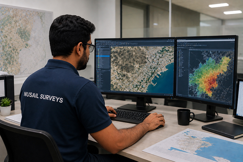
Our GIS Data Services Include:
Remote Sensing Services Utilizing advanced satellite and UAV (Unmanned Aerial Vehicle) technology, we capture high-resolution imagery and data for analysis. Our remote sensing services are crucial for monitoring land use, agricultural health, and environmental changes.
3D Mapping and Modeling Our team creates sophisticated 3D maps and models that provide a deeper understanding of spatial relationships and terrain. These models are invaluable for urban development, infrastructure projects, and environmental assessments.
Spatial Data Analysis Nusail Survey offers in-depth spatial data analysis, helping clients to identify patterns, trends, and relationships within their geospatial data. Our analysis services support decision-making in fields such as resource management, logistics, and public safety.
Custom GIS Solutions We develop customized GIS applications tailored to the specific needs of our clients. Whether it’s a web-based GIS portal or a mobile mapping solution, our custom services ensure that you have the tools necessary to manage and visualize your spatial data effectively.

GIS Data Services
Data Capture & Conversion
Data capture and conversion involve collecting geospatial data from various sources, such as satellite imagery, aerial photography, and field surveys, and converting it into a compatible GIS format. This process ensures accurate and up-to-date information is available for analysis and decision-making.
GIS Database Design
GIS database design focuses on creating a structured and organized geospatial database to store, manage, and analyze spatial data. A well-designed GIS database improves data integrity, query efficiency, and overall system.
GIS Data Sourcing
GIS data sourcing involves the acquisition of spatial data from various sources, such as government agencies, private organizations, and open data repositories. This process ensures that high-quality, relevant, and up-to-date data is used for GIS projects and analysis.
GIS Analysis and Reporting
GIS analysis and reporting involve the processing and interpretation of spatial data to extract meaningful insights and generate reports. This information supports decision-making, policy formulation, and resource management in various fields such as urban planning, environmental management, and public health.
GIS Spatial Analysis
GIS spatial analysis involves the use of specialized techniques to analyze and interpret spatial relationships, patterns, and trends in geospatial data. This type of analysis is essential for understanding complex spatial phenomena and informing decision-making processes.
Data Visualisations
Data visualizations are graphical representations of geospatial data, designed to make complex information more accessible and understandable. These visualizations can include maps, charts, and interactive web applications, helping users explore and interpret spatial data effectively.
GIS Map Printing and Finishing
GIS map printing and finishing involve the production of high-quality, large-format maps and other geospatial products. These services ensure that GIS outputs are presented professionally, with clear symbology, accurate scale, and durable materials suitable for various uses.
GIS Consultancy
GIS consultancy services provide expert advice and support for organizations implementing or improving their GIS capabilities. This can include guidance on system design, data management, analysis techniques, and the integration of GIS with other business systems.
Why Choose Nusail Survey?
- ✔ Advanced Technology: We leverage the latest GIS software and tools to ensure that our clients receive accurate and up-to-date geospatial data.
- ✔ Expert Team: Our team of GIS professionals has extensive experience in handling complex projects across various industries.
- ✔ Tailored Solutions: We understand that every project is unique, which is why we offer customized solutions to meet the specific requirements of our clients.
- ✔ Quality Assurance: At Nusail Survey, quality is our top priority. We adhere to strict quality control processes to deliver reliable and precise data.
Applications of GIS Data Services
- ✔ Urban Planning and Development
- ✔ Environmental Monitoring and Management
- ✔ Infrastructure Management
- ✔ Agricultural Monitoring
- ✔ Disaster Management and Response
- ✔ Transportation and Logistics
- ✔ Telecommunications Network Planning
What we support
Database design, feature coding, spatial analysis and publication-ready cartography for internal or stakeholder use. We can ingest survey CAD, drone outputs and marine grids into a consistent GIS environment where the project requires it.
Applications
- Asset and corridor mapping
- Environmental and planning baselines
- Integration of multi-source survey data
- Map series for reports and public consultation
Geospatial survey portfolio
Our geospatial survey portfolio Oman spans land and marine projects; GIS is often the delivery layer that unifies those inputs. The case studies below emphasise field acquisition—ask us how GIS packaging applies to your dataset.
Related services
Portfolio / Selected case studies
Selected project experience demonstrating Nusail’s capability in land, marine, drone and geospatial survey projects. Full project references can be provided upon request.
Portfolio entries focus on survey acquisition; GIS and mapping deliverables are scoped per contract.
Contact / request quotation
Describe your coordinate reference, layer list, software preferences and sharing constraints.
Oman office
Building No. 9459A, Way No. 897, Mawaleh North, P.O. Box 143, Postal Code 311, Sultanate of Oman