Team Members
As a leading provider of engineering and surveying services in Oman, we pride ourselves on leveraging the latest technologies to deliver precise and efficient solutions. Our expertise in land surveying, hydrographic, and topographic surveys allows us to meet the diverse needs of our clients with precision. We utilize advanced 3D laser scanning, drone topography, and mobile mapping to ensure accurate data collection and analysis, setting us apart as a top survey company in Oman.
Our specialized services also include bathymetric surveys for detailed underwater mapping and exploration. Through the use of cutting-edge remote sensing and GIS technologies, we offer scalable solutions applicable across various industries. Our collaboration with the National Survey Authority of Oman ensures our practices meet national standards, focusing on innovation and sustainability.
Whether employing land survey drones or custom GIS applications, our team is committed to adopting the latest technological advancements. This commitment reinforces our role as a key player in Oman's survey and engineering sector, dedicated to advancing the industry through our comprehensive and innovative solutions.
Issa Al Barmani
Issa Mohammed Ali Al Barmani is the Director of Nusail Engineering Consultancy, bringing a wealth of expertise and over two decades of experience in managing construction projects, particularly in the areas of ports and harbors. He holds a BSc in Civil Engineering from Sultan Qaboos University and an International Port Harbour Association (IPHA) certificate in Port and Harbour Engineering from Japan. Issa has also undergone GIS training and an English course in the UK. His ability to manage multiple contracts and projects, review design specifications, and prepare tenders has been invaluable to our clients. Under his leadership, Nusail Engineering Consultancy has become a trusted name in the industry.
- +968 99455223.
- issa@nusailec.com
Manjini Anandaraj
Manjini Anandaraj has over 25 years of experience managing and analyzing GIS data, civil engineering, remote sensing, and marine/geometric surveying. He has worked extensively in the United Kingdom, Oman, and Saudi Arabia, and is highly skilled in using various software such as ArcGIS Pro, Terrset, AutoCAD Civil 3D, and Bentley Microstation V8i for map preparation, utilities, and highway modeling. In addition, his expertise extends to 3D scanning and drone data processing using Leica Cyclone and Pix4D. Manjini holds a Master of Science in Geographic Data Science from Birkbeck, University of London, and a Bachelor of Technology in Civil Engineering . He is also a member of various professional institutions.
- +44 7440309646
- anand@nusailec.com

Sayeed
Mohammed Sayeed Ahmed is an experienced Engineering Surveyor with over 25 years of Gulf experience in land surveying. He specializes in surveys for infrastructure, highways, bridges, pipe lines, seawall construction, high-rise towers, hotels, villas, and industrial projects. As Operations Director at Nusail Engineering Consultancy, he manages topographic surveys, bathymetric surveys, 3D laser scanning, aerial survey-geo mapping using UAV, GIS, and highway design. Previously, he worked at Carillion plc Qatar as Chief Surveyor, managing the Msheireb Doha Downtown Phase 1B project with 15 buildings, a mosque, and external works. Mohammed holds a Bachelor of Engineering in Civil from Osmania University, Hyderabad, India.
- +968 99209610
- sayeed@nusailec.com

M.T. Sangy
M.T. Sangy is a highly successful professional, with a Master's degree in Business Psychology and a Master's degree in Research from King's College London, UK. Since 2005, she has played an integral role in the growth and success of Nusail Engineering Consultancy. With extensive experience in the engineering consultancy industry, M.T. Sangy has developed exceptional skills in business development and organizational psychology. She is highly skilled in identifying new business opportunities and developing successful marketing strategies. M.T. Sangy's exceptional academic background and professional experience make her a valuable asset to Nusail Engineering Consultancy.
- +44 7958448160
- lee@nusailec.com

Our Expertise
Delivering precision through innovation and experience.
Geospatial & Mapping Solutions
From GIS data management to UAV LiDAR mapping, our team delivers high-resolution geospatial datasets supporting infrastructure, urban planning, and environmental applications across Oman and beyond.
Marine & Bathymetric Surveys
Using multibeam, single beam, and sub-bottom profilers, we deliver precise bathymetric maps and seabed analysis for ports, harbors, and coastal development projects.
Engineering & Topographic Surveys
Our expertise covers topographic, land, and construction surveys, supporting highway design, utility mapping, and large-scale civil infrastructure planning.
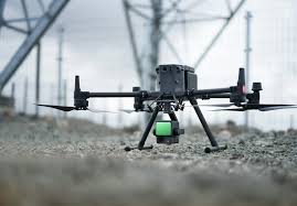
Technology We Use
Combining precision instruments and advanced software to deliver accurate, reliable, and
efficient surveying solutions across Oman and the Middle East.
Cutting-edge Surveying & Mapping Technologies
At NUSAIL Engineering Consultancy, we integrate the most advanced surveying instruments and software to achieve precise, high-quality results in every project. Our team utilizes UAV LiDAR, 3D laser scanning, GPS/GNSS systems, and hydrographic sonar equipment to ensure accurate data acquisition for land, marine, and aerial surveys.
- UAV LiDAR & Drone Mapping
- 3D Laser Scanning & BIM Integration
- Multibeam & Single Beam Echo Sounders
- Sub-Bottom Profilers & Marine Geophysics
- GIS & Remote Sensing Data Processing


Join Our Team
Be part of Oman’s growing geospatial innovation hub.
At NUSAIL Engineering Consultancy, we value talent, dedication, and creativity. Our team thrives on collaboration and continuous learning in the fields of surveying, GIS, LiDAR mapping, hydrography, and remote sensing. If you’re passionate about precision and innovation, we invite you to grow your career with us.
Contact Us